service 2

Radio Quietness For Largest Radio Telescope

LS telcom carries out DTT and GSM coverage simulations and airborne antenna radiation measurements

The Square Kilometre Array, SKA, is an international effort to build the world’s largest radio telescope, with eventually over a square kilometre (one million square metres) of collecting area.
To host the telescope, South Africa’s semi-desert Karoo region was chosen together with Western Australia’s Murchison Shire, for its radio quietness, amongst other scientific and economic reasons. The Karoo regions of South Africa provide the perfect radio quiet backdrop for the high and medium frequency arrays that will form a critical part of the SKA’s ground-breaking telescope spanning continents.
Although South Africa’s Karoo region was chosen for its radio quietness, SKA still has to ensure that DTT and GSM transmission sites, situated closest to the SKA surroundings, will meet the defined interference levels of their radio telescope.

SKA commissioned LS telcom to determine the radiation levels of such DTT and GSM antenna sites. Previously, LS telcom performed coverage simulations and signal strength predictions of existing facilities in the direction of the core area of the radio telescope using the software SPECTRAemc. The results were communicated to SKA and consequently the DTT and GSM site operators which, in a spirit of excellent industry cooperation, reviewed their antenna designs and commenced with the implementation of changes as required.
On SKA’s commission LS telcom then undertook antenna pattern measurements via remotely piloted aircraft (RPA). The remotely piloted aircraft (RPA) carries measurement and high-resolution position and orientation sensors, an autopilot, a high-powered processor and storage unit and a telemetry system. The measurement and navigational data is stored on board and also streamed to the ground control station in real time. The technology determines the horizontal and vertical antenna radiation pattern as well as radiated power. Airborne antenna measurements were done at SKA nominated installations where the performance of the transmission systems was quantified to allow SKA to determine compliancy with their stated radio quiet requirements.
SKA chose LS telcom for their extensive experience in radio frequency studies and measurements.
The final compliancy assessment of these installations will be done by SKA.

image01-1

SYNOPSES – DRONE BASED DATA ACQUISITION IN TELECOMMUNICATIONS

SYNOPSES – DRONE BASED DATA ACQUISITION IN TELECOMMUNICATIONS


Background:

After years of local development and the delivery of successful drone based RF measurements across several continents, LS of South Africa’s prides itself in its offering of in-flight RF antenna radiation pattern characterization, RF scanning services and site auditing.
LS of SA’s unique RF measuring capability using adapted Remote Piloted Aircraft Systems (RPAS), have repeatedly done service in Africa, Europe, Scandinavia, South America and Asia.
LS of SA’s innovative use of drone technology for RF transmission system characterization is clearly raising the level of RF radiation measurement integrity across the industry.
Where LS of SA further supports its spatial RF services with airborne site inspections/modelling, a powerful information base is established for regulatory, planning and operational purposes in the telecommunications industry.
LS of SA is licensed by the South African Civil Aviation Authority as a commercial RPAS services provider. The SACAA accreditation and RPAS Operating Certificate is recognized internationally.


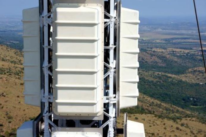
1.  RF Radiation characterization

Ground level RF measurements and/or drive-by assessment of Radio Access Networks is tedious and often inconclusive and very dependent on the ardency of the persons actually doing the work.
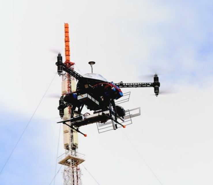
LS of SA’s in-flight RF characterization of operational telecommunication sites facilitates the efficient correlation with drive tests performance outcomes for radio access networks. Iterative site- and antenna hardware corrective actions become simple and efficient where the characteristics of the respective network antenna components are quantified before and after, and in absolute terms.
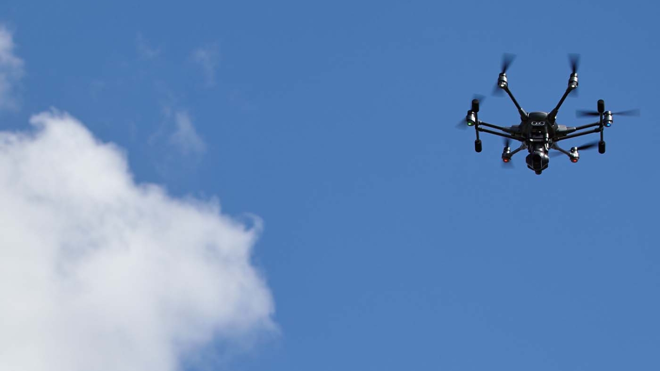
LS of SA’s drones are specifically developed for RF measurement in Broadcasting and Radio Access Networks and are capable of operating in high RF fields typically encountered at such sites.
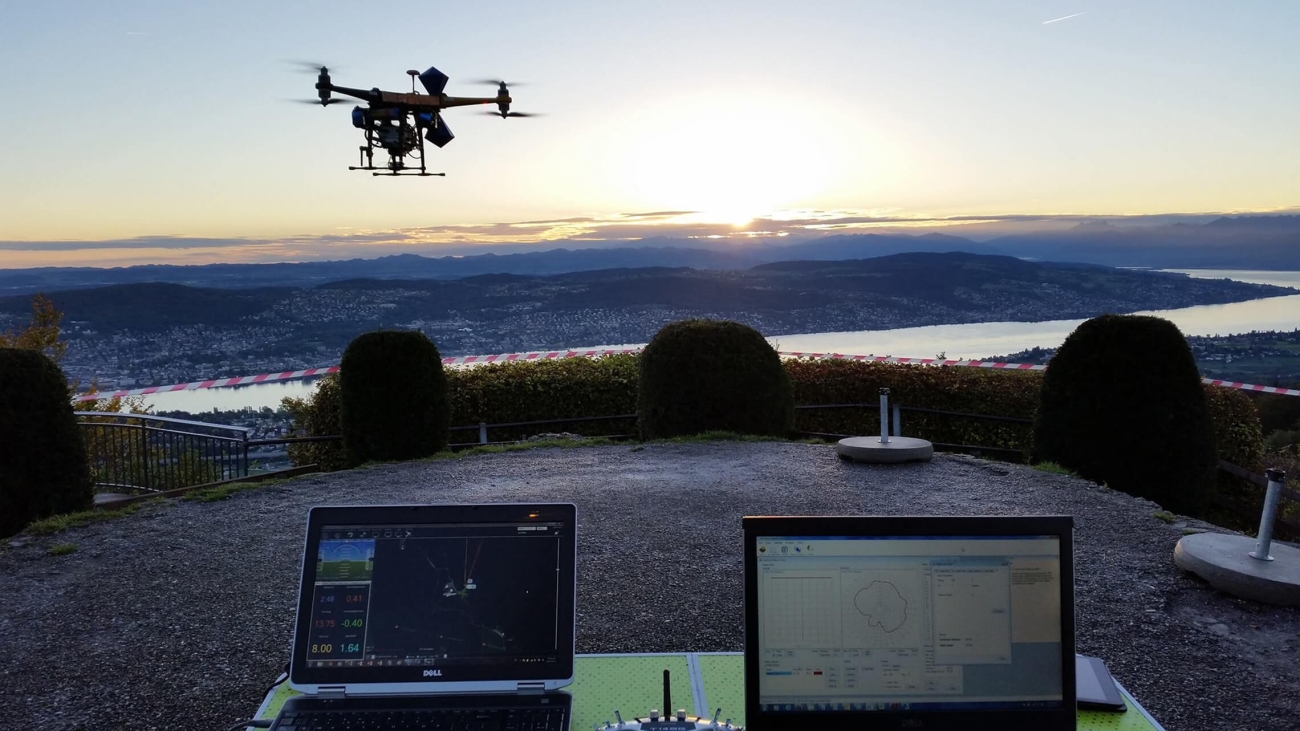
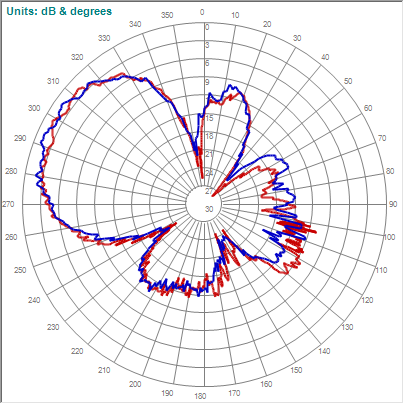
The geo-mapping of the RF measurements are done with high accuracy using the latest on-board RTK navigational technology. Vertical accuracy of lobe definition is typically well within 0.2 degrees.
The LS of SA drone based RF measurement system thus yields unprecedented accuracy for radiation performance of any RF transmission installation and quantifies the outcomes in three dimensions (X, Y, and Z).
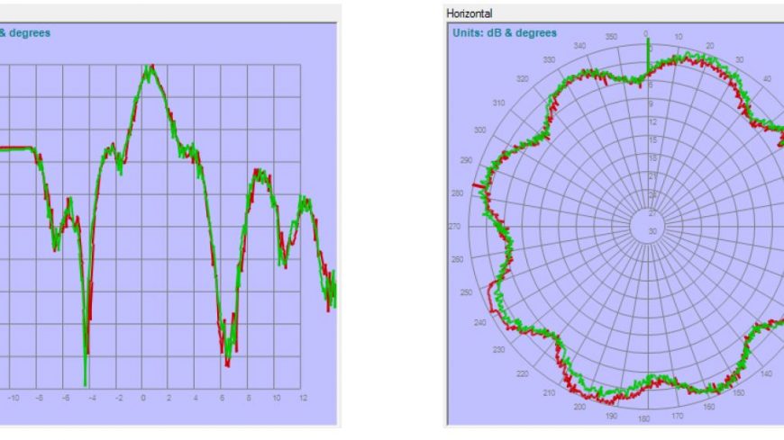
Typical measurement results would include:

  • antenna mounting height and position,
  • azimuth orientation,
  • electrical and mechanical tilt – indicated separately,
  • effective isotropic radiated power,
  • primary and secondary lobe formation.

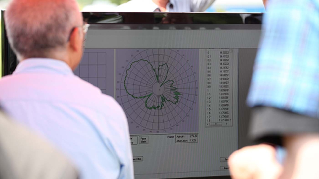
The results are presented graphically and tabulated in a preferred customer format and also in a standard pattern file format.
The aerial measurement process is completely non-intrusive with no human radiation safety risk or service interruptions.


2. RF spectrum scans

LS of SA offers a very useful RF scan service in conjunction with its antenna radiation measurements whereby the actual on-site spectrum utilization is determined. This feature might be deployed in ground level or on LS’s drone platform. Relative transmission levels, azimuth direction and elevation relative to the mast will typically be the outcome of the spectral scan procedure. Bands of interest are focused on.
The aerial scan provides the actual vector determination of spectrum use on site and this information could then inform planning and operational activities.


3. Site modelling/structural inspections

LS of SA offers a transmission site modelling service whereby the site infrastructure and mast is rendered and 3D modelled by photogrammetry processes. High resolution photographs of all site and mast elements are available for any portion of the 3 D model of the site and this allows the customer to “virtually” scrutinize the 3D rendered model in the comfort of his office. This service is particularly suited for the determination of installation quality, operational integrity and rental capacity on the mast structures and site.
The service is offered in synergy with LS of SA’s spectral measurement airborne services.

service 4

COST-EFFECTIVE RADIO FREQUENCY MEASUREMENTS / MAST AUDITS USING REMOTELY PILOTED AIRCRAFT

Consequent to LS telcom’s development of a unique RF measurement vehicle, broadcast and telecommunications operators and regulators will be in a position to determine, in an easy quick and cost-effective manner, the true onsite radiation characteristics of their RF transmission installations. They will also have easy access to high resolution video and photographic recordings of the ground facilities and the mast. These records are extremely useful to determine the technical quality of installations/maintenance on the mast and to establish an inventory of equipment and mounting space on the mast.

THE SERVICE
LS telcom offers this as a turnkey service solution. It is made possible by means of remotely piloted aircraft (RPA), which include either a measurement and sensor system or a camera on-board. The RPA circles the antenna to measure the radiated energy in the azimuth and elevation planes at specific distances from the radiating antennas. While the measurement flights are recorded on board in high definition wide angle video format, a separate RPA specifically equipped with appropriate HD photographic equipment is also available on site for such recordings.

HOW IT WORKS
The complete solution consists of the latest RPA technology which is adapted to carry the measurement sensor, high resolution position and orientation sensors, an autopilot, a high powered processor and storage unit and a telemetry system. The measurement and navigational data is stored on board and also streamed to the ground control station in real time. The RPA flies either totally autonomous or semi-remote controlled and in accordance with a pre-programmed flight path. Several safety features are built into the system amongst which is a ‘return to take-off point’ in the unlikely event of remote control failure.
The distance at which the RPA circles the antenna varies from 50m to 600m depending on the site, the type of measurement, the type of antenna installation and bands to be measured. Flight path distances are typically 3Km long in the broadcasting environment.
This RPA-measurement-service is obviously much more cost-effective than carrying out measurements in an actual manned helicopter. It is also obviously much safer to fly, especially in confined spaces, as it has an accurate flight path on all axes. Any deviations from the flight path are immediately detected and compensated for in the end result.
In flight differential GPS positional referencing is done for all measurement.
In addition to broadcast facility measurements, this solution is also ideally suited to do mobile communication site measurements. Obviously such measurements cannot be carried out by a conventional helicopter.

FINAL TESTS COMPLETED
While this approach may seem fairly logical and easy to realise for the layman, the development of this solution spans a number of years where a huge number of iterations were covered to finally produce the accurate results currently possible. These include parameters for calibration, stabilisation, navigation, positioning, data streaming and the quality and repeatability of the actual measurements. All of this needs to function flawlessly in extreme RF radiating areas and under challenging environmental conditions such as on high mountain tops.
This is why, after the proof of concept last year following a five-year research and development period, the system has undergone another series of extensive tests and now guarantees reliable results as well as high stability and safety.

THE DELIVERABLES
The deliverables of the in-flight measurement service include horizontal (HRP) and vertical radiation patterns (VRP) and effective radiated power (ERP) per service. The performance of the transmission system can thus be accurately
quantified. The results may be used, in turn, to determine coverage deviations from the design intention. The measurements for all programmes for a single transmission technology can be carried out in one flight. To confirm the absolute reliability of the results, all flights are duplicated and the results overlaid for the benefit of the customer.
The deployment of the photographic RPA brings great additional value by providing details for mast inventory, such as antenna type, height, status of paint work and rust on the mast. It enables desktop assessment of the installation and infrastructure, before and/or after the work of installation and maintenance teams. This is especially convenient and advantageous where climbing up the mast is cost-intensive and normally requires down-time of the transmitter for inspection.

THE ADVANTAGES IN BRIEF
The advantages for network operators of this revolutionary service are two-fold: not only can they optimise network coverage and guarantee expected service level to their customers in a cost-effective way; they will also be able to reduce their infrastructure maintenance cost.
This equipment inventory service also allows operators to easily and quickly quantify any possibly available space for rental to third parties.
Interest in this service offering was received worldwide.

The RPA with the measurement payload
Typical raw measurements results of an 8 tier 4 bay UHF antenna duplicated and overlaid
Lightning strike erosion on the lightning arrestor
Condition of VHF antenna panels and covers
Untitled-6

Demonstration flights at LS telcom HQ

Introduction

Each year LS telcom plays host to their annual summit in the small town of Lichtenau, bordering the Rhine River and famous Black Forrest. During this time they showcase mostly their own latest developments to regulators and operators from around the globe. During the 2013 LS telcom summit, LS of South Africa was also invited to demonstrate the measurement and flying capabilities of their unique airborne antenna radiation pattern measurement solution.

The demonstration

For the demonstration a small 12.5m mast was erected on an open field on the LS telcom grounds. A local amateur radio enthusiast built and sponsored a yagi antenna that was fitted to the mast. In a nearby tool shed a signal generator provided a small 6dBm continues wave signal at 434MHz to the antenna.

During the summit a large LCD television was connected to the PC running the measurement software. This provided the audience with a chance to view each step of the measurement which included the real-time measurement display. This display function draws the actual pattern as it is measured.

After a short burst of rain the LS of SA team took to the field and performed a number of measurements.

Results

After a couple of horizontal flights were performed and overlaid the LS of SA team could confirm the antenna pattern. This pattern can be seen below: